![]()
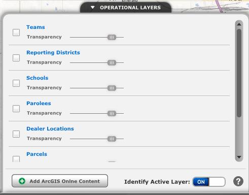
Operational Layers Tab
What is the purpose of the Operational Layers Tab?
-
The Operational Layers tab displays all the Operational Layers available.
-
Operational layers are used as a reference when viewing data on the map.
-
An operational layer consists of point, line or polygon geography.
-
Operational layer symbology and information may change depending on the zoom level of the map to reveal more detailed features as the map scale decreases.
How do Operational Layers work?
-
The Operational Layers available to you will depend upon your Dashboard's configuration.
-
Operational layers can be turned off and on with the check box next to each layer.
-
The transparency for each operational layer can be changed with the sliding bar below the layer title.
-
Clicking on an Operation Layer makes it the Active Layer and allows you some additional options.
-
You can re-order the Operational Layers with the Up and Down arrows. Note: This will not persist outside your current session.
-
You can zoom to the layer with the Zoom icon.
-
Depending on your Dashboard's configuration you can view metadata with the Information button.
-
Depending on your Dashboard's configuration you can remove an operational layer from the list. Note:This will not persist outside your current session.
-
The Identify Active Layer On/Off will allow you to choose whether the Identify dialogue will show when you click on a feature of the Active Layer.
-
The Add ArcGIS Online Content button will allow you to add layers from ArcGIS Online. Click here to read more about ArcGIS Online.
Operational Layer Dialogue Box
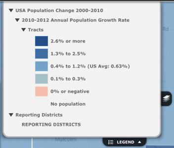
Operational Layers Legend
-
The legend component has been updated with the capability to display legends for both preconfigured operational layers and those operational layers added through ArcGIS Online.
-
A legend will be displayed when an operational layer is visible on the map unless the layer is published from an ArcGIS Server running 10.0 or below.
-
Only those layers published from an ArcGIS Server running 10.0 SP1 and higher have the new legend capability.
The Operational Layers Legend
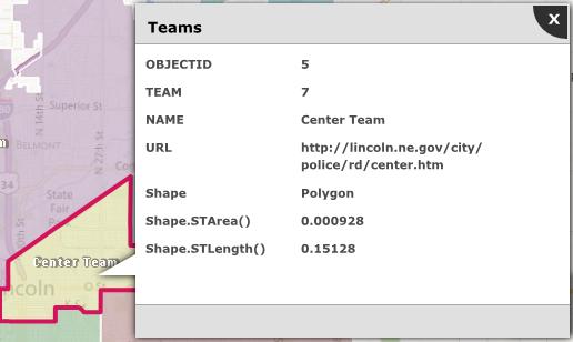
Operational Layers Identify
-
Operational layers, both the predefined layers and those added from ArcGIS Online, now support the identify functionality.
-
The identify functionality searches only the active operational layer.
The Operational Layer Identify.
Related Links:
© Copyright 2011 The Omega Group. All Rights Reserved.